Why the answer depends on the definition#
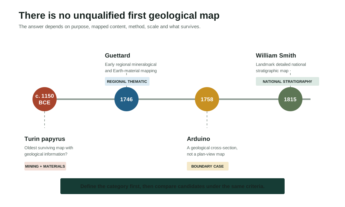
There is no responsible single answer until "geological map" is defined. The Turin mine papyrus, made in ancient Egypt around 1150 BCE, is a leading candidate for the oldest surviving map with geological information. Jean-Etienne Guettard's 1746 map is a major candidate for early systematic thematic mapping of Earth materials. Giovanni Arduino's 1758 Agno Valley drawing is an unusually advanced geological section rather than a conventional plan-view map. William Smith's 1815 work is a landmark large, stratigraphically informed national map, but it was not the first artifact ever to display geology.
Each statement answers a different priority question. Calling any candidate simply "the first geological map" hides the criteria that made it win.
Define the category before choosing a winner#
A map can contain geological information without having been created within modern geology. It can plot mineral locations, distinguish rock types, trace strata, or reconstruct their order underground. It may be a field sketch, cross-section, manuscript, published sheet, regional survey, or national synthesis.
This audit uses five questions:
- Form: Is the object a plan-view map, a route map, a diagram, or a vertical section?
- Content: Does it show isolated resources, areas of different material, boundaries between units, or an interpreted stratigraphic sequence?
- Method: Were observations collected and generalized systematically, and is the method recoverable?
- Scale and coverage: Does it map one route, a valley, a region, or most of a country?
- Evidence and survival: Is the artifact securely dated and documented, and does "first" mean earliest made, earliest surviving, or earliest published?
Change the criterion and the answer can change. "Oldest surviving map that differentiates rock materials" is not the same claim as "first published national stratigraphic map."
Claims-audit tool
Compare the candidates
Filter by map job. The candidate changes when the definition changes.
| Date | Candidate | What it maps | Claim status | Rights note |
|---|---|---|---|---|
| c. 12th century BCE | Turin mining papyrusAncient Egyptian expedition administration; probable association with the scribe AmunnakhtEvidence: A002 S017 | Routes, terrain, quarrying and mining features, and differentiated material zones | Leading candidate for the oldest surviving map with substantial geological information | Underlying artifact is ancient; the museum image and reconstruction require an item-level rights check |
| 1746 | Mineralogical map of France and EnglandJean-Etienne Guettard with cartographer Philippe BuacheEvidence: S014 S077 | Broad bands of surface materials and reported mineral occurrences | Major early published regional attempt to generalize the distribution of Earth materials | Use catalogue facts and citations; clear any reproduction of a surviving sheet separately |
| 1758 | Agno Valley geological representationGiovanni ArduinoEvidence: A004 S015 | A longitudinal rock sequence and superposed mountain orders | Early field-based lithostratigraphic cross-section, not a conventional plan-view map | The IUGS record may be cited; its displayed images require a separate rights check |
| 1774 | Volcano-geomorphological map of part of AuvergneFrancois Pasumot and Dailley in collaboration with Nicolas DesmarestEvidence: A014 S015 | Basalt flows, volcanic sources and landscape relationships used to interpret extinct volcanism | Landmark early thematic map connecting mapped landforms to a geological process history | The map object and any modern scan require an item-level rights check |
| 1799 | Map around BathWilliam SmithEvidence: S070 S077 | Strata around Bath | Regional precursor to Smith's later national stratigraphic synthesis | Clear the exact surviving map image and holding institution before reuse |
| 1809 | Geological map of the United StatesWilliam MaclureEvidence: A013 S077 | Broad rock classes across the then United States using a modified Wernerian framework | First published geological map of the United States under the USGS account; predates Smith's 1815 map | Use the official record for facts; clear any map scan or derivative separately |
| 1815 | A Delineation of the Strata of England and Wales with part of ScotlandWilliam Smith with publisher and cartographer John CaryEvidence: S013 S070 S077 | Ordered stratigraphic units and their national-scale surface distribution | Landmark detailed national stratigraphic map, not the first geological-information map of every kind | Surviving copies and digital reproductions have collection-specific terms |
| 1819 | Geological map of England and WalesGeorge Bellas Greenough and Geological Society networksEvidence: S070 S077 | Compiled geological units at national scale | Early national synthesis whose sources and relationship to Smith require explicit historical treatment | Clear the exact edition, holding institution and digital reproduction before reuse |
The rights column concerns images of the historical objects. This original comparison table does not reproduce those maps.
The comparison tool also includes Desmarest's 1774 volcano-geomorphological map of Auvergne, William Maclure's 1809 United States map, Smith's Bath precursor, and Greenough's 1819 synthesis. They prevent the four category-defining examples below from being mistaken for an exhaustive ranking.
Four category-defining candidates#
| Candidate | Date and form | Strongest defensible claim | Important limit |
|---|---|---|---|
| Turin mine papyrus | About 1150 BCE; route and topographic map | Oldest surviving map with substantial geological information under a widely used interpretation | It was made for quarrying, transport, and administration, not as a modern stratigraphic survey |
| Guettard map | 1746; published regional thematic map | Major early attempt to map the distribution of Earth materials across parts of France and England | Its broad mineralogical bands are not a modern formation map |
| Arduino Agno Valley drawing | 1758; longitudinal geological cross-section | Early field-based representation of a lithostratigraphic sequence | A cross-section is not a plan-view geological map |
| Smith map | 1815; large national-scale published map | Landmark detailed stratigraphic map of England and Wales with part of Scotland | Earlier geological, mineralogical, and national maps existed |
The table is not a ranking. It records what each object demonstrates and where its priority claim stops.
Turin: the oldest surviving geological-information map#
The artifact usually called the Turin mine map or Turin Gold Mine Papyrus represents part of Wadi Hammamat in Egypt's Eastern Desert. The Museo Egizio papyrus catalogue calls it one of the earliest known geographical maps. Its catalogue description identifies roads through wadis, settlements and sacred features, quarrying information, alluvial deposits, gold-bearing areas, and mountains differentiated by color and material.
James Harrell and V. Max Brown went further in their peer-reviewed analysis, whose title calls it "The World's Oldest Surviving Geological Map". They interpreted the map's black and pink hills as differentiated sedimentary and igneous or metamorphic rocks and connected the drawing to a quarrying expedition during the reign of Ramesses IV.
Those are attributed claims, not interchangeable labels. The museum's current catalogue uses cautious geographic wording; Harrell and Brown defend the geological classification. Both support a strong conclusion: this surviving object maps a real landscape and conveys material information relevant to stone and gold extraction.
Its ownership and production also require care. The museum says the papyrus came from Deir el-Medina and that its owner was probably the village scribe Amunnakht, son of Ipuy, because much of the writing is in his hand. That does not justify silently converting "probable owner" into a certain sole cartographer. The catalogue also records acquisition in Egypt by Bernardino Drovetti between 1814 and 1821 and sale into the royal collection in 1824. These details belong in the object's provenance, not in a simplified discovery legend.
The Turin candidate wins if the criterion is oldest surviving map with substantial geological information. It does not automatically win a category restricted to published products of systematic modern geological science.
Guettard: an early systematic regional attempt#
In 1746, Jean-Etienne Guettard presented a mineralogical map spanning parts of France and England. The French national geological service, BRGM, describes Guettard's work as the first attempt at a geological map. It showed broad bands of sandy, marly, and schistose terrain and proposed regularity in the distribution of stones, metals, and other materials.
A Geological Society of America history of William Smith's map attributes the 1746 publication to Guettard and cartographer Philippe Buache and notes its attempt to show the distribution of chalk across France and England. It also explains a limitation: later Guettard and Lavoisier maps plotted rock and mineral observations but did not yet map strata in Smith's sense.
Guettard is therefore a persuasive answer to "Who made an early published regional map that generalized surface materials?" The answer should retain the period term "mineralogical" and acknowledge the cartographic collaboration. Calling the sheet identical to a modern bedrock formation map would erase the very development the history is meant to explain.
Arduino: why sections complicate the word map#
Giovanni Arduino investigated the Agno Valley in northern Italy and drew a detailed longitudinal representation of its rocks in 1758. The International Union of Geological Sciences heritage record describes the drawing as a reconstruction of a sequence along the valley and connects Arduino's observations to his later four-unit lithostratigraphic theory.
The work maps geological relationships in an everyday sense, but its form is a cross-section: it shows rocks through distance and depth rather than their areal distribution from above. That distinction matters. Geological sections are essential companions to maps because they turn surface observations into an interpretation of the subsurface. They are not automatically candidates in a contest restricted to plan-view cartography.
Arduino's inclusion improves the audit precisely because he is a boundary case. Under a criterion such as "early field-based image that organizes rock units stratigraphically," his 1758 section is exceptionally important. Under "first plan-view geological map," it should not displace a plan-view artifact.
Smith: a national stratigraphic landmark, not an absolute first#
William Smith's A Delineation of the Strata of England and Wales with part of Scotland was published in 1815. It brought together extensive field observation, surveying, ordered strata, fossils, geological boundaries, and a striking system of hand coloring at a large geographic scale. John Cary supplied crucial cartographic and publishing expertise; a careful history should not make the finished sheet appear to be free of collaboration.
Smith's method is the source of his lasting priority. He recognized that strata could be ordered and identified across distance, including through their characteristic fossils. That connection between mapping and fossil succession is explained further in how fossils help geologists date rocks. The GSA analysis documents how Smith used lines and graded color to show strata and how his geological interpretation developed across multiple map issues.
The same GSA source states plainly that Smith did not make the first geological map. Guettard's 1746 publication preceded him, and William Maclure published a geological map of the United States in 1809. The British Geological Survey accordingly discusses Smith within the origins of systematic geological mapping in Britain, where his map informed later survey color practices.
A defensible description is "a landmark early national-scale stratigraphic geological map." Depending on carefully stated definitions, it is also described as the first detailed geological map of a whole country or Britain's first national geological map. It should not be reduced to "the world's first geological map."
How to audit a priority claim#
When a museum label, textbook, or search result says "first," test the sentence before repeating it:
- Quote the exact category. Does it say geological, mineralogical, stratigraphic, national, detailed, published, or surviving?
- Check whether the date refers to observation, drawing, presentation, publication, or a later edition.
- Identify the object. A route map, cross-section, manuscript sketch, and printed national sheet are not the same format.
- Separate contemporary purpose from later interpretation. An ancient mining document can carry geological information without sharing modern disciplinary aims.
- Name collaborators and institutions when the evidence supports them.
- Prefer collection records and primary scholarship over celebratory summaries.
- Record uncertainty rather than turning "probably" or "often described as" into certainty.
This method is useful beyond maps. Many "founder" and "first discovery" claims in the history of geology become clearer once the object, criterion, and evidence are stated separately.
Provenance and image rights are different questions#
Historical importance does not create a free license to copy a digital image. An ancient papyrus or an 1815 printed map may be outside copyright as an underlying work, while a museum photograph, scan, annotated reconstruction, or scholarly figure can have separate terms. Ownership of the physical object, copyright in a reproduction, database access rules, and the factual information in a catalogue are also different things.
Before publishing an image:
- Record the holding institution and exact catalogue identifier.
- Link to the collection record and retain its provenance language.
- Check the institution's current image-use and licensing terms for that specific file.
- Credit the artifact, creator when known, holding institution, photographer or digitizer, and license as required.
- Do not assume that an image copied into a paper inherits the artifact's public-domain status.
For example, the Turin object is assembled from multiple catalogue fragments, while surviving Smith maps exist in multiple issues and collections. A visually similar file may therefore represent a different object state or carry different reproduction terms.
The criterion-based verdict#
The evidence supports several answers, each with an honest scope:
For the oldest surviving map with geological information, the Turin mine papyrus is the leading candidate. For a major early published regional attempt to map Earth materials, Guettard's 1746 map is a strong answer. For an early stratigraphic cross-section, Arduino's 1758 Agno Valley drawing is pivotal. For a landmark national stratigraphic map, Smith's 1815 map remains foundational.
That wording is less memorable than declaring one winner, but it is more useful. It shows how geological mapping developed through practical resource knowledge, field observation, sections, classification, fossils, surveying, printing, and collaboration rather than appearing in a single moment.
Sources and further reading
Citations are placed beside the claims they support. This list gathers the external sources used on this page.
- Turin Gold Mine PapyrusMuseo Egizio | official museum collection record
- The world's oldest surviving geological map: The 1150 B.C. Turin papyrus from EgyptJames A. Harrell and V. Max Brown | peer-reviewed article
- 1746: The early days of geological mappingBureau de recherches géologiques et minières | official institutional history
- The Development and Evolution of the William Smith 1815 Geological MapGeological Society of America authors | scholarly society article
- Arduino's lithostratigraphical sequence of the Agno ValleyInternational Union of Geological Sciences, International Commission on Geoheritage | official international geoscience heritage record
- The origins of systematic geological mapping in BritainBritish Geological Survey | official institutional history
Continue learning
- Place the map in contextThe History of Geology: How Scientists Learned to Read Earth's Deep HistoryTrace how field evidence, instruments, institutions and theories changed.
- Use fossils to correlate layersHow Fossils Help Geologists Date RocksWork through fossil correlation, numerical anchors and common failure modes.
Check a claim against the references above, then read our corrections and sourcing standards.