When geology became a science#
There is no single defensible founding date. Modern geology took recognizable form between the late seventeenth and early nineteenth centuries, then continued to change through laboratory science and geophysics.
A useful sequence is:
| Milestone | Why it matters | Why it is not a complete founding date |
|---|---|---|
| 1669 — Steno | A systematic method for interpreting fossils and layered rocks | He worked within early-modern natural philosophy; later geologists named, extended, and qualified the principles |
| 1788–1795 — Hutton | A cyclic, process-based Earth requiring immense duration | His system was one program among several and depended on later exposition and field debate |
| 1807 — Geological Society of London | A permanent institution for shared observations, maps, collections, and argument | Geology was developing outside London and outside Europe |
| 1815 — Smith’s map | National-scale stratigraphic mapping tied to fossils and practical surveying | Earlier geological-information maps existed; mapping alone did not constitute the whole discipline |
| 1830–1833 — Lyell’s Principles | A highly influential statement of historical method and present causes | Geology was already active, and Lyell neither invented every method nor settled every controversy |
The best concise answer is therefore: geology emerged as an organized modern science through a long transition, with especially important consolidation from roughly 1669 to the 1830s. It became increasingly professional, quantitative, and international later in the nineteenth and twentieth centuries. S005 S006 S009 S011 S013 S052
What geology means—and what this history covers#
Geology is the science of Earth and planetary materials, structures, processes, and history. Geologists reconstruct that history from field relationships, rocks, minerals, fossils, sediments, chemical and physical measurements, geophysical signals, experiments, remote sensing, and models. It is much more than “the study of rocks,” although rocks are one of its most important archives.
Earth science and geoscience are broader or overlapping umbrella terms. Depending on the institution, they may include geology, geophysics, geochemistry, hydrology, oceanography, atmospheric science, cryosphere science, soil science, and planetary science. This history uses geology for the discipline centered on the solid Earth and its history, while acknowledging that modern geological problems routinely cross those boundaries. S060 S061
Several neighboring fields require distinction:
| Term | Working definition in this article |
|---|---|
| Natural philosophy | Premodern and early-modern inquiry into nature before today’s disciplinary structure |
| Natural history | Description, collection, comparison, and classification of natural objects and organisms |
| Mineralogy | Minerals, their structures, compositions, properties, occurrences, and formation |
| Stratigraphy | Layered rocks and sediments, their sequence, correlation, and time relationships |
| Paleontology | Past life through fossils and related evidence |
| Petrology | The origin, composition, texture, and transformation of rocks |
| Lithology | Description of a rock unit’s physical characteristics |
| Geomorphology | Landforms, surface processes, and landscape evolution |
| Geophysics | Physical measurements and models of Earth, including seismology, gravity, magnetism, heat flow, and geodesy |
| Geochemistry | Chemical and isotope behavior in Earth and planetary systems |
| Sedimentology | Transport, deposition, alteration, and interpretation of sediment |
| Tectonics | Deformation and large-scale structure of crust and lithosphere |
| Plate tectonics | The framework of moving lithospheric plates, spreading, subduction, and transform boundaries |
| Geological time scale | The standardized hierarchy used to organize Earth history and its corresponding rock record |
This article is the history of geology, meaning the history of knowledge, methods, institutions, and theories. It is not a complete geological history of Earth, which would narrate events from planetary accretion through the present.
Method and evidence controls#
This reconstruction uses four rules.
- Do not turn useful ancient observations into modern theories. A marine fossil found inland can support a conclusion about former environments without making its observer a plate tectonicist, paleoclimatologist, or professional geologist.
- Do not turn a later slogan into an exact historical quotation or doctrine. Labels such as uniformitarianism, catastrophism, Neptunism, and “father of geology” often compress internally varied programs.
- Separate evidence from interpretation. A rock contact, fossil, isotope ratio, or seismic arrival is an observation or measurement. A reconstruction of uplift, extinction, age, or mantle structure is an interpretation evaluated by how well independent evidence converges.
- Treat standards and hazards as versioned information. The International Chronostratigraphic Chart used here is version 2026/06. The formal Anthropocene Epoch proposal was rejected in the 2024 IUGS–ICS decision, although the term remains useful informally. Both statements must be checked again when this page is updated. S001 S002 S003 S004 S080
Part I — How geological knowledge changed#
The six major transformations in geological knowledge#
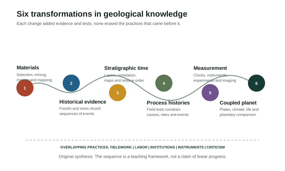
The history can be understood through six overlapping transformations rather than a parade of heroes.
1. From using geological materials to systematizing them#
Humans learned which stones fracture predictably, which clays harden, which pigments persist, where water accumulates, and how ores behave in a furnace. This knowledge was experimental in a broad sense: choices were tested through repeated work. Yet it was often embodied in craft, oral instruction, landscape familiarity, and labor rather than formal texts. Mining and quarrying later created repeated access to underground sections, veins, faults, groundwater, and rock contacts. Printed works such as Agricola’s De re metallica made some of this knowledge portable, while still depending on the skills of miners and metalworkers. S008 S039 S040 S076
2. From objects to historical evidence#
A shell embedded in a mountain can be classified as a curious stone, a medicinal object, an organism transported by a flood, or evidence that the rock formed in a former sea. The crucial transformation was not merely recognizing resemblance to organisms; it was building reliable rules for inferring how the enclosing rock and the body entered their present relationship. Steno’s 1669 reasoning helped establish that rocks and fossils could record sequences of events. Later workers expanded the method through unconformities, cross-cutting relations, fossil succession, sedimentary structures, and regional correlation. S006 S045 S074 S005
3. From local layers to ordered geological time#
Before numerical dating, geologists built a relative chronology. A lower layer was generally older than a higher one in an undisturbed sequence; a fault or intrusion cutting a rock was younger than the rock; fossil assemblages helped identify positions in a sequence. Mapping showed how units continued, changed, or disappeared across landscapes. The geological time scale grew from many regional schemes and priority disputes, not from one master chart. Its formal international structure remains under maintenance today. S001 S002 S013 S015 S080
4. From speculative Earth systems to testable process histories#
Eighteenth- and nineteenth-century theorists proposed oceans precipitating universal rock sequences, internal heat lifting land, catastrophes resetting life, and present processes explaining past change. These were not just abstract philosophies: they directed attention to different rocks, structures, rates, and field sites. Geology matured as explanations were forced to survive comparison among maps, sections, fossils, active processes, and incompatible regional evidence. The surviving methodological core is actualism: use tested natural processes and laws to interpret the past, without assuming that rates or configurations were always identical. S009 S010 S011 S012 S005
5. From relative history to measurement and imaging#
Microscopes revealed rock textures; chemistry quantified minerals; seismographs recorded waves; gravity and magnetism exposed hidden structure; radioactivity supplied clocks; high-pressure experiments reproduced deep conditions; drilling recovered cores; satellites and GPS measured motion; tomography produced model-based images of the interior. Geological knowledge did not become less historical when it became quantitative. Measurement gave historians of Earth new ways to test sequences, rates, and mechanisms. S018 S019 S020 S043 S055 S075
6. From separate phenomena to a coupled planet#
Plate tectonics connected continents and oceans, earthquakes and volcanoes, ridges and trenches, mountain building and crustal recycling. Earth-system science then connected the solid planet to oceans, atmosphere, ice, life, and human activity. Planetary geology extended comparative reasoning to the Moon, Mars, Venus, icy worlds, and meteorites. The result is not a finished doctrine but a hierarchy of models tested across scales. S024 S025 S026 S027 S028 S029 S030 S058 S059
These transformations overlapped. Practical miners continued to matter after universities formed; descriptive mapping remained essential after mass spectrometry; catastrophic events fit within actualist geology; and plate tectonics did not eliminate regional stratigraphy, petrology, or unresolved questions about the deep Earth.
How geologists know#
Geology is an inference science, but inference does not mean speculation without constraint. Its strongest conclusions are supported by different evidence systems that can fail in different ways.
- Field relationships. Contacts, faults, folds, intrusions, unconformities, and sedimentary structures reveal relative sequence and deformation.
- Rocks and minerals. Composition, texture, crystal structure, and alteration constrain origin and conditions.
- Fossils. Organisms, traces, and assemblages help reconstruct environments, evolution, extinction, and relative age.
- Stratigraphic succession. Repeated vertical and lateral patterns allow regional and global correlation.
- Physical and chemical measurements. Isotope ratios, elemental compositions, temperatures, pressures, magnetic remanence, and material properties supply quantitative tests.
- Geophysical imaging. Seismic waves, gravity, magnetism, electrical methods, and heat flow constrain inaccessible structures.
- Experiments and numerical models. Controlled systems and equations test whether proposed processes can produce observed records.
- Satellites and remote sensing. Repeated global observations measure motion, elevation, deformation, mineral signatures, ice, water, and surface change.
No one system is infallible. Field records can be incomplete; fossils can be reworked; isotope systems can be disturbed; inverse models can be nonunique; experiments simplify nature; remote-sensing signals require calibration. Confidence rises when independent methods agree and when a model predicts observations not used to construct it. S053 S055 S018 S027 S029
Geological scale: from atoms to planets, seconds to billions of years#
Geologists connect a hierarchy of spatial scales:
Atom and isotope
    ↓
Crystal lattice
    ↓
Mineral
    ↓
Rock and sediment
    ↓
Outcrop, core, or specimen
    ↓
Landscape, volcano, glacier, aquifer, or basin
    ↓
Crust and lithosphere
    ↓
Continent and ocean basin
    ↓
Mantle and core
    ↓
Whole planet and planetary system
The temporal hierarchy is equally wide. A seismic rupture unfolds in seconds; a flood or eruption in hours to years; a river terrace or magma chamber over longer intervals; a basin over millions of years; a supercontinent cycle over hundreds of millions; planetary differentiation and evolution over billions. A central geological skill is deciding which observations can be linked across scales without assuming that a laboratory sample, a modern decade, or one outcrop represents the whole system.
How theories change#
Geological theories change through more than “new facts.” They change when instruments expose a new domain; maps reveal a regional pattern; expeditions bring incompatible evidence; measurements constrain rates; models make risky predictions; and one framework unifies observations formerly housed in separate disciplines. Social institutions matter as well: journals, surveys, mines, navies, universities, museums, colonial administrations, funding systems, and access to ships or instruments determine which evidence can be gathered and who is credited. S023 S030 S031 S039 S040
A disciplined confidence vocabulary is useful:
| Category | Meaning |
|---|---|
| Direct observation | A described feature, specimen, event, or relationship that can in principle be checked |
| Measurement | A value produced by a documented method with uncertainty and calibration |
| Strongly supported interpretation | An explanation supported by multiple independent lines of evidence |
| Model-dependent inference | A conclusion requiring assumptions that should be stated and tested |
| Disputed interpretation | A live or historical disagreement among qualified researchers |
| Obsolete historical explanation | A once-serious model no longer supported as a general account |
| Unsupported popular myth | A claim contradicted by evidence or lacking a traceable basis |
Selected chronology
Geological knowledge did not follow one straight line
Twelve points sampled from the 58-record research timeline. Dates, institutions and practices overlap rather than forming a single ladder of progress.
- PrehistoryPeople select, transport, shape, heat-treat, and exchange stone, clay, pigments, and ores.Global
- c. 6th century BCEReports associated with Xenophanes connect marine shells or impressions found inland with past environmental change.Eastern Mediterranean
- 11th centuryIbn Sina discusses mountain formation, minerals, petrification, and fossil-like objects within natural philosophy.Persianate world
- 1556Agricola's De re metallica is published.Central Europe
- 1788James Hutton publishes his Theory of the Earth paper.Scotland
- 1815William Smith publishes his large geological map of England and Wales with part of Scotland.Britain
- 1830s–1840sCharles Darwin conducts and publishes geological studies of uplift, subsidence, volcanic islands, coral reefs, and South American geology.South America and Pacific
- 1882The Geological Survey of Japan begins institutional work.Japan
- 1913Arthur Holmes publishes The Age of the Earth.Britain
- 1957–1958The International Geophysical Year coordinates observations of Earth, oceans, atmosphere, ice, and magnetism.Global
- 1969–1972Apollo missions return lunar samples for laboratory study.Moon
- 2026-06ICS issues version 2026/06 of the International Chronostratigraphic Chart.International stratigraphy
Part II — Knowledge before the modern discipline#
Practical geological knowledge before writing#
The oldest geological knowledge is recoverable mainly through artifacts and landscapes, not statements of theory. Stone tools reveal selective use of fracture, grain, hardness, and durability. Pigments record mineral procurement and processing. Ceramics require knowledge of clay behavior and heat. Mines and quarries show that people recognized veins, layers, weathering zones, and workable rock. Long-distance movement of obsidian, flint, jade, metals, and pigments demonstrates that geological materials were embedded in exchange, identity, power, and specialized labor.
What these remains do not reveal securely is a prehistoric philosophy of Earth. Archaeologists can reconstruct choices and operational sequences, but not assume that a community divided nature into “mineral,” “rock,” and “geological process” as modern textbooks do. The responsible conclusion is that practical material knowledge was sophisticated and consequential while its conceptual vocabulary remains only partly recoverable. S076
Ancient Egypt: administration, extraction, and mapping#
Ancient states recorded stones, metals, pigments, building materials, and trade. In Egypt, quarrying and mining demanded route knowledge, water planning, labor organization, and recognition of useful rock. The Turin mining papyrus, usually dated to the Ramesside period, depicts a desert route and differentiates material zones associated with quarrying or gold mining. Harrell and Brown argued that it is the oldest surviving geological map; museum interpretation likewise emphasizes its geological information. Yet the label depends on the criteria. If a geological map means any spatial depiction that distinguishes rock or mineral bodies, the papyrus is a powerful candidate. If it means a systematic map constructed from a formal stratigraphic survey, the comparison with modern maps becomes misleading. S016 S017 S015
This distinction matters throughout the history. Administrative and technical knowledge can be precise without sharing the goals of modern explanatory science. A quarry map answers where materials and routes are. Stratigraphy asks how rock bodies relate in time and space. A plate map represents a dynamic model. One artifact need not satisfy all three jobs to be historically important.
Greek and Roman natural philosophy#
Ancient Greek and Roman writers preserved observations of fossils, sediment, springs, earthquakes, volcanoes, and mineral substances. Reports about Xenophanes connect marine remains found inland with former conditions. Herodotus reasoned about Nile sediment and the growth of the delta. Aristotle and later commentators developed causal systems for meteorological and subterranean phenomena. Theophrastus’s On Stones organized stones and mineral substances by properties, origins, and uses. Strabo described landscapes and regional change; Seneca discussed earthquakes and waters; Pliny assembled an enormous natural-historical account of minerals, mining, and marvels. S007 S046 S005
The temptation is to search these texts for the first modern answer. That method creates false victories. A correct observation can sit within a causal system unlike modern geology; a passage preserved through later authors may be fragmentary; and resemblance to a later idea does not establish a transmission line. Their importance lies in the range of questions, observations, and material practices they preserve—not in awarding modern disciplinary titles retrospectively.
South Asian mineral, metallurgical, and landscape traditions#
South Asia has long histories of mining, metallurgy, stone working, gem knowledge, hydraulic engineering, soil classification, and landscape description. Sanskrit and regional texts, artisanal traditions, courtly expertise, and later Persianate scholarship contain material classifications and technical knowledge. The challenge is evidentiary. “Ancient Indian geology” can become an empty prestige claim if modern concepts are projected onto terms whose purposes were medical, ritual, commercial, architectural, or metallurgical.
A careful history asks narrower questions: What substance was described? How was it identified? What operation was performed? Who used the knowledge? What manuscript or artifact preserves it? How did colonial surveys later recruit, translate, ignore, or recategorize local expertise? The formation of the Geological Survey of India in 1851 did not create knowledge of the subcontinent from nothing. It did create a powerful colonial institution that organized observations around coal, minerals, mapping, administration, and imperial economic priorities. Its publications need to be read alongside histories of labor, translation, land access, and extraction. S037 S038 S039 S076
China and East Asia#
Chinese traditions linked mineral resources, hydraulic works, geography, mapping, earthquakes, and landscape observation. Shen Kuo’s eleventh-century Dream Pool Essays is frequently cited for reasoning from marine fossils in mountains, erosion and deposition, and petrified bamboo found where the contemporary climate did not support bamboo. These are historically striking observations. But “the first paleoclimatologist” is a modern honorific, not a neutral translation of Shen’s intellectual project. The safest claim is that he used material evidence to reason about long-term environmental and landscape change within Song-era scholarship. S047
Modern institutional geology in East Asia developed through translation, education, state surveys, mining, military and industrial demands, and local scientific adaptation. The Geological Survey of Japan, founded in the Meiji period, became one node in an international network of maps, specimens, standards, and experts. Japanese seismology and volcanology later grew partly because recurrent hazards made instruments and monitoring socially urgent. A full regional history must not imply that modern institutions merely copied Europe; imported categories were translated and transformed under local conditions. S035 S043
Islamic-world scholarship#
Arabic- and Persian-language scholarship preserved, criticized, translated, and extended Greek natural philosophy while contributing original work in geography, geodesy, mineralogy, medicine, mechanics, and measurement. Al-Biruni measured densities and Earth dimensions and wrote about minerals and gems. Ibn Sina discussed mountains, minerals, petrification, and bodies found within stone. Their works belong to intellectual settings in which modern boundaries among geology, physics, medicine, cosmology, and philosophy did not exist. S048 S049 S050
Two errors should be avoided. The first is exclusion: treating later European geology as if it developed without multilingual traditions of texts, instruments, materials, and measurement. The second is forced anticipation: claiming that a short passage already contained a complete modern theory. Demonstrable transmission should be documented through manuscripts, translations, citations, teaching, or institutional contact rather than asserted because two ideas appear similar.
Medieval Europe: lapidaries, mines, and scholastic Earth questions#
Medieval European lapidaries mixed physical properties, uses, symbolism, medicine, and inherited authorities. Scholastic natural philosophy debated matter, change, waters, fossils, and Earth structure. Meanwhile miners, quarry workers, masons, metalworkers, and builders maintained operational knowledge. These domains interacted unevenly. A miner could know that a vein changes across a fault without writing a general theory of faults; a scholar could discuss petrification without visiting a mine.
The standard story in which theology simply stopped Earth inquiry is inadequate. Religious commitments shaped questions and acceptable interpretations, but there was no single medieval position. The stronger historical point is institutional: the later discipline required sustained field comparison, specialist publication, maps, collections, and communities capable of correcting one another. Those structures were still developing. S005 S008 S076
Part III — From Renaissance natural history to stratigraphic Earth history#
Mining, print, collections, and the Renaissance field#
The expansion of mining, print, cartography, specimen collecting, and state administration changed what could be known. Agricola’s De re metallica described mine planning, ore treatment, surveying, ventilation, drainage, machinery, and hazards in unusual detail. It did not present plate tectonics or a modern geological time scale. Its significance is methodological and social: mines exposed three-dimensional relationships, and print connected practical observations to readers beyond a single district. S008 S076
Leonardo da Vinci’s notebooks contain acute observations of fossil shells, sedimentary layers, erosion, and the implausibility of transporting delicate shells to mountains in one brief event. Because much of this material remained unpublished, later influence cannot be assumed from modern rediscovery. Cabinets and museums also mattered. Specimens made distant regions comparable, but collections removed objects from their field relationships. Geology would repeatedly negotiate the tension between the specimen and the place.
Steno and the historical reading of layered rocks#
Nicolas Steno’s 1669 De solido intra solidum is one of the clearest turning points. He asked how a solid body could be naturally contained inside another solid. Fossils resembling teeth or shells could be understood as once-organic bodies enclosed as sediment became rock. Layers could be ordered through geometrical relationships. Modern textbooks associate Steno with superposition, original horizontality, and lateral continuity. Those labels are useful, but the historical text should not be rewritten as a current lab manual. S006 S045 S074
Three implications were profound.
- Sequence: in a relatively undisturbed sedimentary stack, lower layers generally formed before overlying layers.
- Deformation: if layers now stand tilted or broken, events occurred after deposition.
- Missing record: erosion and truncation can remove earlier materials, so Earth history is not a complete book with every page preserved.
Steno did not single-handedly found a finished science. His method became powerful because later geologists tested, named, qualified, and connected it to mapping and fossils. Deposits can form on slopes; strata can be overturned; organisms can be reworked; intrusions can complicate sequences. Principles work through field diagnosis, not mechanical recitation.
Seventeenth- and eighteenth-century theories of Earth#
Early-modern Earth theories combined scripture, classical philosophy, mechanical science, chemistry, mining, fossils, and observations of active processes. Thomas Burnet imagined a structured sacred history of Earth; John Woodward placed fossils and strata within a flood-based system; Robert Hooke argued from fossils and Earth changes; Edmond Halley proposed physical clocks; Buffon experimented with cooling spheres and composed a long physical history. The period was not a battle between one fixed religious chronology and modern truth. Scriptural chronologies differed, natural histories differed, and some writers held multiple temporal frameworks at once. S005 S020
Theories mattered because they selected evidence. A universal ocean encouraged comparison of sequences. Internal fire directed attention to volcanoes and intrusions. Flood models focused on transport and deposition. Cooling models invited measurement. Their weaknesses became visible as regional maps and fossil successions resisted universal schemes.
Neptunism, mining academies, and Werner's influence#
At Freiberg, Abraham Gottlob Werner built an influential teaching system around minerals, field recognition, mines, and a broad Neptunist history in which major rock units formed from a retreating primeval ocean. “Neptunism versus Plutonism” is often told as a simple duel between water and fire. In practice, classifications, regional sequences, volcanic rocks, veins, basalts, and institutional loyalties generated multiple disputes.
Werner’s power came partly from pedagogy. Students carried field methods and terminology across Europe and beyond. Mining academies show why disciplinary history cannot be read only from famous publications: classrooms, collections, examinations, state employment, and technical careers create durable communities.
Hutton, unconformities, and a cyclic Earth#
James Hutton’s theory described a habitable Earth maintained through cycles. Weathering and erosion wore land down; sediments accumulated; internal heat consolidated and uplifted new land; erosion began again. An unconformity could preserve the geometry of multiple cycles: older rocks tilted and eroded, younger layers deposited across them, then the whole sequence exposed. Such relationships implied durations vastly beyond written history. S009 S010 S005
The famous phrase about finding no vestige of a beginning and no prospect of an end is associated with Hutton’s published argument, but its popularity owes much to John Playfair’s lucid exposition and later commemoration. Hutton’s system had limitations. It was teleological in presenting Earth as a machine sustaining habitation; its mechanisms were incomplete; and not every rock controversy can be collapsed into Hutton versus Werner. His durable contribution was a way of combining field relationships, cycles, and observable causes into a historical system.
Fossils, extinction, and past worlds#
Fossils became more than curiosities when they could identify lost organisms, correlate strata, and reconstruct environments. Georges Cuvier used comparative anatomy to argue that fossil mammals were not merely living species in unknown places. Extinction became an empirically compelling conclusion. With Alexandre Brongniart, he connected fossil assemblages and strata in the Paris Basin. Earth history could contain successive biotas and discontinuities. S012 S005
The word catastrophism hides important differences. Cuvier’s regional revolutions, later global catastrophe schemes, and modern studies of impacts or megafloods are not one doctrine. Geologists today use actual causes to study events across a wide spectrum of rates. A meteorite impact can be both catastrophic and scientifically actualist. The historical lesson is not that slow always defeated fast. It is that rates, extents, mechanisms, and recurrence must be established from evidence.
The worked lesson on how fossils help date rocks shows how assemblages establish relative order and how independent dated layers calibrate that sequence.
William Smith, fossil succession, and the map as an argument#
William Smith learned strata through practical work in surveying, drainage, coal, canals, and engineering. He recognized that layers occurred in a consistent order and could be identified through characteristic fossils. His 1799 Bath-area work, 1801 general map, and 1815 national-scale publication converted vertical order into a spatial system. The map did not merely decorate a theory: its colored pattern was an argument that strata continued beneath soil and across terrain. S013 S070 S072 S077
Smith’s 1815 map is often called “the first geological map.” That is too broad. The Turin papyrus mapped geological materials for mining; Guettard and other eighteenth-century naturalists produced mineralogical and lithological maps; regional maps preceded Smith. What made Smith’s work exceptional was its large scale, stratigraphic method, practical integration, fossil correlation, and influence. A defensible title is a landmark early national stratigraphic geological map. S014 S015 S016 S017
Maps also distribute credit unevenly. Surveying depends on land access, local information, fossil identification, engraving, coloring, copying, and finance. Later state maps could make territory legible to science and infrastructure while also serving extraction, taxation, military planning, and colonial rule.
The first geological map claims audit separates Smith's national stratigraphic achievement from earlier maps and sections with different purposes.
Lyell, actual causes, and a maturing discipline#
Charles Lyell’s Principles of Geology asked readers to explain former changes of Earth’s surface through causes now in operation. His books assembled modern earthquakes, volcanoes, rivers, coasts, sedimentation, and biological change into a methodological program. They influenced Darwin and generations of geologists. S011 S044
Yet “uniformitarianism” is not one simple belief. Historians distinguish at least:
- uniformity of natural law;
- use of present processes to interpret past evidence;
- preference for gradual rates;
- claims that rates or overall states remained broadly uniform;
- rejection of particular directional Earth histories.
Modern geology retains the first two as methodological actualism. It does not require every event to be slow, every rate constant, or every environment repeated. Lyell’s opponents were not a single anti-scientific bloc, and Lyell’s own positions changed across editions and subjects.
By the 1830s, geology had many features of a recognizable discipline: societies, journals, maps, field excursions, museums, surveys, disputes over nomenclature, and a growing professional identity. It still excluded many people from formal membership and depended on commercial and informal collectors. Mary Anning’s expertise and specimens, for example, were central to British paleontology even though class and gender limited her institutional standing. S041 S052
The comparison of uniformitarianism, catastrophism and actualism explains why modern geology retains tested natural processes without assuming constant rates or excluding rare catastrophes.
Part IV — Building geological time, institutions, and quantitative methods#
The geological time scale before numerical dating#
The familiar names Cambrian, Ordovician, Silurian, Devonian, Carboniferous, Permian, Triassic, Jurassic, and Cretaceous were not revealed at once or laid out from oldest to youngest by one authority. They emerged from regional fieldwork, fossil correlation, national traditions, and bitter boundary disputes. A “system” is a rock-based chronostratigraphic unit; its corresponding interval of time is a “period.” Similar distinctions apply between series/epoch and stage/age.
Relative dating used several principles:
- superposition in suitable sequences;
- cross-cutting relationships;
- inclusions and baked contacts;
- unconformities;
- fossil succession;
- lateral correlation;
- later, magnetic polarity and chemical signals.
The scale is therefore a negotiated empirical framework anchored to physical reference sections and globally correlatable signals. The International Commission on Stratigraphy now coordinates formal units. Numerical boundary ages are useful estimates but can be revised; in much of the Phanerozoic, the formal definition rests on a ratified Global Boundary Stratotype Section and Point rather than a number alone. Formal names and boundary ages are versioned. This article was checked against chart 2026/06; readers should use the current official chart for later revisions. S001 S002 S080
Glacial geology and the discovery of ice ages#
Scattered boulders, polished rock, scratches, moraines, and broad valley forms demanded explanation. Floods, floating ice, and local glaciers were among competing proposals. In the Alps, Ignaz Venetz and Jean de Charpentier developed evidence that glaciers had once extended far beyond their modern limits. Louis Agassiz promoted a much broader Ice Age theory and became its best-known advocate.
This is another priority trap. Agassiz did not observe all the evidence first, and local people familiar with Alpine terrain contributed observations that elite publications rarely credited. The broader scientific achievement was linking a suite of landforms and deposits to moving ice, then recognizing repeated glaciations. Later deep-sea cores, isotope records, lake sediments, loess, speleothems, and ice cores transformed glacial geology into paleoclimate science.
Geological surveys: public science and state power#
National surveys made geology durable. They trained staff, standardized symbols, accumulated archives, published maps, and connected field observation to mines, railways, water, agriculture, military planning, and public works. The Geological Survey of Great Britain began in 1835; the Geological Survey of Canada in 1842; the Geological Survey of India in 1851; the U.S. Geological Survey in 1879; the Geological Survey of Japan in 1882. Institutional dates, however, can conceal predecessor projects and later reorganizations. S032 S033 S034 S035 S037
Surveys were not politically neutral cameras. Colonial governments sought coal, metals, routes, and administratively legible territory. Field geologists depended on guides, miners, porters, translators, collectors, landholders, and communities. Local knowledge could be extracted into a map while its source disappeared from authorship. Modern national surveys also deliver enormous public value—hazard maps, groundwater data, baseline geochemistry, open maps, and environmental advice. A complete history must hold both truths: survey science can be methodologically rigorous and socially embedded. S038 S039 S040
The map record is easier to evaluate when purpose, collaborators, field context and later revisions are kept visible. The first geological map claims audit applies explicit criteria to the Turin papyrus, Guettard, Arduino, Desmarest, Maclure and Smith rather than assigning one context-free winner.
Geology and Darwin#
Charles Darwin was a geologist before he was publicly known for evolution. During and after the Beagle voyage, he studied uplifted coasts, South American strata, volcanic islands, earthquakes, coral reefs, and long-term subsidence. Geological reasoning taught him to reconstruct unseen sequences from incomplete traces and to treat small observable processes as capable of large cumulative effects under suitable conditions. S044 S073
Geology and evolutionary biology then developed in dialogue. Fossils supplied succession and extinction; stratigraphy ordered records; evolutionary theory explained biological change; biostratigraphy used organisms for correlation. But the fossil record was never simply a complete ladder. Preservation, sampling, facies, erosion, and taxonomic practice shape what is available.
The laboratory enters the rock#
Nineteenth-century geology is often pictured as fieldwork with a hammer. Field evidence remained central, but instruments changed the discipline.
The polarizing microscope and thin section made mineral textures visible. Crystallography supplied mathematical structure. Chemical analyses quantified composition. Experimental petrology later reproduced melting and mineral stability at controlled pressure and temperature. Thermodynamics linked mineral assemblages to conditions. Geochemistry traced elements and isotopes through reservoirs. These approaches turned a hand specimen into a record of crystallization, deformation, metamorphism, fluid flow, and source.
Seismographs provided a different kind of section. Earthquakes generated waves whose arrival times changed with internal materials. Mohorovičić inferred a crust–mantle discontinuity; Inge Lehmann inferred a solid inner core. These are not photographs of inaccessible layers. They are model-based conclusions supported by wave paths, reflections, refractions, normal modes, gravity, magnetism, mineral physics, and other constraints. S043 S055
How scientists determined the age of Earth#
Geologists first ordered events without a numerical clock. Fossil succession, superposition, cross-cutting relationships and unconformities established relative sequence. Nineteenth-century estimates based on cooling, sediment accumulation and ocean chemistry then forced researchers to state physical assumptions, but each clock simplified an open, changing Earth. John Perry's critique of Lord Kelvin is especially instructive: convection could change the thermal calculation even before radioactive heat was fully understood. S020 S022
Radioactivity supplied a different kind of clock. Patterson's 1956 lead-isotope work was pivotal, but the accepted age of about 4.54 billion years is a convergent solar-system inference supported by meteorites, multiple isotope systems, ancient terrestrial minerals, lunar samples, calibrated decay constants and explicit tests for disturbed samples. The dedicated lesson explains how scientists determined the age of Earth and why the answer does not depend on one rock or one assumption. S018 S019 S075
From description to geophysics#
By the early twentieth century, geologists confronted questions that field mapping alone could not answer: the depth of the crust, the nature of the core, the strength of continents and oceans, the source of mountain building, and the age and structure of the seafloor. Seismology, gravimetry, magnetism, heat flow, and radioactivity shifted authority toward physical measurement. This did not make older field geology obsolete. It created conflicts over acceptable explanation and prepared the conditions for the continental-drift controversy.
Part V — From continental drift to plate tectonics#
A mobile Earth becomes a testable system#
Alfred Wegener made continental mobility a serious research problem by bringing together continental fit, fossils, rock belts and paleoclimate evidence. His proposal was not already plate tectonics: its forces were inadequate, and continents were imagined moving through ocean floor. Reception differed by country and discipline, so the history is more useful than a simple story of ridicule followed by vindication. S023 S024
The decisive evidentiary change came from the oceans. Sounding and seismic work revealed ridges, trenches and thin oceanic crust; Marie Tharp and collaborators made the connected ridge system visible; paleomagnetic measurements and symmetrical magnetic anomalies supplied testable records of seafloor creation; earthquake geometry, transform faults, subduction and plate motion on a sphere connected the observations into a global kinematic framework. No one result or person supplied the whole theory. S025 S026 S027 S028 S029 S031
By the late 1960s, plate tectonics explained why oceanic lithosphere forms at spreading centers, moves as part of plates and returns to the mantle at subduction zones. The focused lesson compares continental drift and plate tectonics by what moves, how boundaries connect and which observations distinguish the frameworks.
Part VI — Geology after the revolution#
Satellites, GPS, tomography, and numerical Earth#
Plate tectonics arrived as computing, satellites, and global networks expanded. Very-long-baseline interferometry and GPS now measure plate and crustal motion directly. Satellite radar can map deformation associated with earthquakes, volcanoes, groundwater withdrawal, landslides, and ice. Gravimetry tracks mass changes. Remote sensing identifies structures, minerals, landforms, and environmental change.
Seismic tomography uses differences between observed and predicted wave travel to estimate three-dimensional velocity structure. Images of slabs and mantle anomalies are not direct photographs. They are inverse solutions whose resolution depends on earthquake and station geometry, parameterization, and assumptions. Responsible visualizations should show depth, scale, resolution limits, and model provenance. S055
Mass spectrometers measure isotope ratios with precision unimaginable to early geochronologists. High-pressure presses and diamond-anvil cells test minerals under deep conditions. Numerical geodynamics explores convection, rifting, collision, and core processes. Digital geological maps and GeoSciML-style standards make features interoperable, but data standardization raises questions about category translation, versioning, and who controls foundational datasets. S078
Environmental geology and society#
Geology is embedded in public decisions.
- Groundwater: aquifer geometry, recharge, contamination pathways, and subsidence.
- Landslides: materials, slopes, rainfall, earthquakes, and land modification.
- Earthquakes: faults, recurrence, ground motion, site response, and probabilistic hazard.
- Volcanoes: magma movement, eruption histories, monitoring, and hazard zones.
- Coasts: sediment budgets, subsidence, uplift, storms, and sea-level change.
- Waste and contamination: transport, containment, geochemistry, and long-term performance.
- Resources: ores, aggregates, energy materials, and critical-mineral systems.
- Climate archives: sediments, fossils, isotopes, ice, soils, caves, and weathering.
- Carbon storage: reservoir, seal, faults, reactions, pressure, monitoring, and leakage risk.
- Urban geology: foundations, tunnels, fill, groundwater, heat, and buried infrastructure.
Historical knowledge is not a live warning. A page about earthquake science cannot tell a reader that a location is safe today. Reliable major-earthquake prediction specifying time, place, and magnitude is not available; probability and hazard assessment are different. Current alerts must come from the responsible national or regional agency. In the United States, USGS provides live earthquake and volcano information, but international pages must route users to the correct local authority rather than treating USGS as universal. S056 S057 S079
Geological risk is not the same as geological hazard#
A hazard is a potentially damaging process or condition. Risk depends on hazard plus exposure, vulnerability, and capacity. Two communities exposed to similar shaking can suffer different outcomes because of buildings, infrastructure, preparedness, inequality, and governance. Geological maps are therefore inputs to decisions, not self-executing declarations of safety.
Planetary geology#
Geology expanded beyond Earth when telescopic observations, meteorites, spacecraft images, geophysical measurements, and returned samples made other worlds available to comparative study. Lunar mapping and Apollo samples established a chronology of impacts, volcanism, differentiation, and crust formation. Mars missions reveal sedimentary rocks, deltas, volcanic provinces, ice, weathering, and environments that changed through time. Venus, Mercury, icy satellites, asteroids, and dwarf planets broaden the range of tectonic, volcanic, impact, and surface processes.
Planetary geologists use analogs carefully. An Earth lava field can help test an instrument or interpret morphology, but another planet has different gravity, atmosphere, temperature, composition, and history. Similar appearance does not guarantee identical process. NASA’s planetary-analogs program explicitly uses terrestrial environments to understand other worlds while missions supply their own observations. S058 S059
Meteorites also make planetary geology central to Earth history. They constrain solar-system age, differentiation, impacts, and the materials from which planets formed. The boundary between geology and astronomy becomes porous when the question is how rocky bodies originate and evolve.
Geology in the twenty-first century#
Current geology operates in several simultaneous modes:
- Field and core observation remain indispensable for relationships, samples, and ground truth.
- High-precision laboratories reconstruct ages, temperatures, sources, fluids, and reactions.
- Monitoring networks track earthquakes, volcanoes, deformation, water, and environmental change.
- Three-dimensional models integrate surfaces, boreholes, geophysics, and uncertainty.
- Earth-system research links tectonics, climate, oceans, life, weathering, and biogeochemical cycles.
- Planetary missions test geological reasoning under unfamiliar boundary conditions.
- Open data and computation enable reuse but demand provenance, reproducibility, and responsible uncertainty.
- Public-facing geoscience must communicate hazards without pretending to predict what cannot be predicted.
Critical minerals, carbon storage, geothermal energy, groundwater stress, urban growth, and climate adaptation make geological expertise economically and politically consequential. That increases the need for conflict-of-interest disclosure, clear uncertainty, community engagement, and separation of education from promotion.
The Anthropocene: formal unit versus historical concept#
The Anthropocene is a strong example of how scientific, historical, and public meanings can diverge. Researchers use the term to discuss human alteration of sediments, biogeochemical cycles, climate, ecosystems, and planetary processes. A formal chronostratigraphic unit, however, must pass specific procedures and be anchored to a globally correlatable boundary. IUGS and ICS rejected the proposal to formalize an Anthropocene Epoch in 2024 while affirming continued informal use. Therefore:
- Do not label the Anthropocene an officially ratified epoch.
- It may be discussed as an informal geological and interdisciplinary concept.
- State the date and authority of the status check.
- Recheck the ICS chart and statements during every scheduled update.
As of August 26, 2026, this draft uses the ICS 2026/06 chart and the existing IUGS–ICS decision. S001 S002 S003 S004
Part VII — Firsts, founders, and misconceptions#
Why “first” claims fail so often#
Priority claims appeal because they compress complexity into a memorable person and date. They fail when the underlying category changes.
- The first geological map changes depending on whether a mining map, mineralogical map, lithological map, stratigraphic map, or national survey map is required.
- The first geologist changes depending on whether observation, written causal explanation, professional identity, field method, or institutional employment is required.
- The discovery of deep time changes depending on whether one means imagining a long past, making it physically necessary, estimating it, or measuring it numerically.
- The invention of plate tectonics dissolves because the framework required distinct discoveries by many teams.
A full machine-readable audit accompanies this article. The recommended editorial rule is simple: never use first, father, founder, invented, discovered, proved, or the moment in a title or factual sentence unless the category, evidence, competitors, and confidence are stated.
Condensed firsts-and-founders audit#
| Popular claim | Evidence-controlled conclusion |
|---|---|
| “Steno was the first geologist” | Steno was foundational to stratigraphic and fossil reasoning; the professional category came later |
| “Hutton was the father of geology” | Hutton was a major architect of cyclic, process-based deep-time geology; modern geology had many origins |
| “Smith made the first geological map” | Smith made a landmark 1815 national stratigraphic map; earlier geological-information maps exist |
| “Cuvier discovered extinction” | Cuvier established extinction with unusually powerful comparative-anatomical evidence |
| “Lyell invented uniformitarianism” | Lyell popularized an influential actual-cause program; the label combines several ideas and was coined by another writer |
| “Wegener proved plate tectonics” | Wegener developed continental drift, a crucial but mechanically different precursor |
| “Hess invented plate tectonics” | Hess supplied seafloor spreading; many researchers supplied other indispensable components |
| “Patterson dated Earth from one rock” | Patterson’s 1956 work was pivotal; the modern age is a convergent solar-system inference |
S006 S009 S013 S015 S019 S023 S025 S030
Misconceptions corrected#
“All premodern scholars thought Earth was exactly 6,000 years old”#
Historical chronologies were diverse. Some Christian scholars calculated dates near that order from genealogies, but textual interpretations, philosophical cycles, and other religious and regional cosmologies differed. Moreover, a chronology of human or sacred history did not always function as a measured physical age of the planet. S005
“Uniformitarianism means every change is slow”#
Modern actualism permits earthquakes, eruptions, impacts, landslides, outburst floods, and rapid climate transitions. The test is whether the process and scale are supported, not whether the event is gradual. S011 S005
“The fossil record is a complete timeline”#
Fossilization is selective. Exposure, collection, taxonomy, depositional environment, erosion, metamorphism, and sampling all filter the record. Fossils are powerful because patterns recur and can be combined with stratigraphy, dating, and phylogeny—not because every organism is preserved.
“Radiometric dating is circular because fossils date rocks and rocks date fossils”#
Relative fossil succession and numerical isotope dating are different evidence systems. An igneous ash layer can be dated radiometrically and bracket a fossil-bearing sediment; fossils can correlate that interval to another basin; magnetic or chemical markers can provide additional tests. Apparent circularity disappears when the actual chain of observations is shown. S053 S054 S020
“Cutaway diagrams show what scientists have seen”#
Deep-Earth diagrams are models constrained by seismic, gravitational, magnetic, thermal, experimental, and cosmochemical evidence. They should be labeled as interpretations. The fact that the core is not directly visible does not make the inference arbitrary; it makes uncertainty and convergent evidence essential. S055
“The time scale is a fixed list of names”#
The scale is standardized but versioned. Numerical ages and some formal definitions change as new GSSPs are ratified and measurements improve. Reproducing the ICS chart also involves explicit permission rules, particularly for modified or commercial use. The current official chart should be consulted directly; an educational diagram may explain its facts without copying the chart's protected design. S001 S002 S062
“The Anthropocene is officially on the chart”#
It is not, under the cited decision. Informal use remains valid when clearly labeled. S003 S004
“Geology predicts earthquakes”#
Geology and seismology assess faults, recurrence, ground motion, and probabilities. They do not currently produce reliable major-earthquake predictions specifying exact time, place, and magnitude. Claims of exact major-earthquake prediction are not supported by the cited evidence. S057
What the history teaches about scientific change#
The strongest lesson is not that science advances in a straight line from superstition to truth. Geological knowledge grows through:
- better access to places and materials;
- rules for preserving field context;
- more comparable maps and classifications;
- instruments that reveal previously invisible domains;
- theories that connect evidence without ignoring anomalies;
- replication and cross-checking;
- institutions that preserve data and train people;
- criticism of the social purposes and exclusions built into those institutions.
A theory can be rationally rejected under one evidentiary regime and later revived in transformed form when new measurements change the problem. A famous scientist can be right about a central claim and wrong about the mechanism. A map can be scientifically valuable and politically entangled. A model can be indirect yet strongly constrained.
Conclusion#
Humans learned to read Earth by turning materials into evidence and evidence into sequences, maps, clocks, and models. The process began long before geology had a name and continues after plate tectonics. Practical knowledge of stone, ore, water, and terrain supplied observations. Natural philosophers asked how mountains, fossils, earthquakes, and seas changed. Steno helped formalize the historical reading of layers. Eighteenth- and nineteenth-century field workers, fossil researchers, mappers, societies, and surveys built a relative history. Laboratories measured composition and age. Ocean and seismic instruments revealed a mobile planet. Satellites and spacecraft extended the same inferential discipline across Earth and other worlds.
No single founder owns that history. Its most powerful achievements—deep time, extinction, the time scale, Earth’s age, plate tectonics, and internal structure—are convergent arguments assembled by communities using different evidence. That is why geology deserves to be taught not as a list of conclusions but as a method for reasoning from incomplete records.
The field’s future will depend on the same discipline: observe carefully, preserve provenance, quantify uncertainty, compare independent evidence, expose model assumptions, correct priority myths, acknowledge labor and power, and keep live standards separate from durable history.
Sources and further reading
Citations are placed beside the claims they support. This list gathers the external sources used on this page.
Browse all 68 cited sources
- Earth's Deep History: How It Was Discovered and Why It MattersMartin J. S. Rudwick | academic book
- De solido intra solidum naturaliter contento dissertationis prodromusNicolas Steno | digitized primary book
- Theory of the Earth; or an Investigation of the Laws Observable in the Composition, Dissolution, and Restoration of Land upon the GlobeJames Hutton | digitized primary paper
- Principles of Geology, volume 1Charles Lyell | digitized primary book
- William Smith 1815 Geological Map of England and Wales with part of ScotlandBritish Geological Survey | official collection record
- A brief history of the Geological Society of LondonGeological Society of London | official institutional history
- Discovering GeologyBritish Geological Survey | official educational hub
- Subject Areas in GeologyGeological Society of London | professional-society educational page
- International Chronostratigraphic ChartInternational Commission on Stratigraphy | official standard
- ICS International Chronostratigraphic Chart receives update 2026/06International Commission on Stratigraphy | official update
- The Anthropocene: IUGS-ICS Joint StatementInternational Union of Geological Sciences and International Commission on Stratigraphy | official statement
- The Anthropocene: IUGS-ICS StatementInternational Union of Geological Sciences | official statement
- International Commission on StratigraphyInternational Commission on Stratigraphy | official standards body
- De re metallicaGeorgius Agricola; translated by Herbert Clark Hoover and Lou Henry Hoover | digitized primary book
- Recognizing the colonial history attached to geological mapsA. A. Baboolal | peer-reviewed article
- Reflecting on the Colonial Legacy of Geoscience in AfricaMultiple authors | peer-reviewed perspective
- Mining and the Formation of Modern GeologyEzio Vaccari | academic reference chapter
- Nicolas StenoUniversity of California Museum of Paleontology | university educational source
- Niels Stensen's Dissertation on a Solid Naturally Contained Within a SolidInterdisciplinary Encyclopedia of Religion and Science | specialist translation/commentary
- The earliest geological maps: a critical reviewMarco Romano | peer-reviewed article
- Illustrations of the Huttonian Theory of the EarthJohn Playfair | digitized primary book
- Essay on the Theory of the EarthGeorges Cuvier; translated by Robert Kerr | digitized primary book
- Geologic Time: Age of the EarthU.S. Geological Survey | official educational source
- Age of meteorites and the EarthClair C. Patterson | original scientific paper
- The Age of the EarthG. Brent Dalrymple | academic book
- Earthquake Science TimelineU.S. Geological Survey | official timeline
- The Interior of the EarthU.S. Geological Survey | official educational publication
- Powell Expedition—Geologic Time. Then and Now.U.S. Geological Survey | official educational article
- Historical perspective: From continental drift to plate tectonicsU.S. Geological Survey | official educational source
- Harry Hammond Hess: Spreading the seafloorU.S. Geological Survey | official educational source
- J. Tuzo Wilson: Discovering transforms and hotspotsU.S. Geological Survey | official educational source
- Magnetic anomalies over oceanic ridgesFrederick J. Vine and Drummond H. Matthews | original scientific paper
- A new class of faults and their bearing on continental driftJ. Tuzo Wilson | original scientific paper
- The North Pacific: an example of tectonics on a sphereDan McKenzie and Robert L. Parker | original scientific paper
- Scientific Controversies: Continental Drift to Plate TectonicsHenry R. Frankel | academic history chapter
- Planetary AnalogsNASA | official space-agency educational source
- NASA Planetary ScienceNASA | official space-agency overview
- Dating Rocks and Fossils Using Geologic MethodsNature Education contributors | scientific educational article
- The Rejection of Continental Drift: Theory and Method in American Earth ScienceNaomi Oreskes | academic book
- About Marie TharpLamont-Doherty Earth Observatory, Columbia University | official institutional biography
- The Stories of the Oldest Geological Map of Mankind: The Turin Gold Mine PapyrusMuseo Egizio | museum source
- The world's oldest surviving geological map: The 1150 B.C. Turin papyrus from EgyptJames A. Harrell and V. Max Brown | peer-reviewed article
- On StonesTheophrastus; translated by Earle R. Caley and John F. C. Richards | translation of primary text
- XenophanesJames H. Lesher and Stanford Encyclopedia of Philosophy editors | academic reference entry
- 175 Years of Service by the Geological Survey of IndiaGeological Survey of India authors | institutional scholarly article
- Economic Compulsions and the Geological Survey of IndiaDeepak Kumar | academic article
- The first evidence for climate changeGeological Society of London blog | specialist educational article
- History of the Geological Survey of JapanGeological Survey of Japan, AIST | official institutional history
- al-Bīrūnī, Abū RayḥānJan P. Hogendijk | academic reference entry
- Al-Biruni Commemorative VolumeUNESCO | institutional scholarly volume
- Ibn Sina and the development of Earth sciencesMuslim Heritage editors and cited scholars | specialist secondary article
- The origins of systematic geological mapping in BritainBritish Geological Survey | official institutional history
- William Smith — a man who changed the worldBritish Geological Survey | official institutional history
- The Development and Evolution of the William Smith 1815 Geological MapGeological Society of America authors | scholarly society article
- 1746: The early days of geological mappingBureau de recherches géologiques et minières | official institutional history
- The geology of the voyage of the BeagleCharles Darwin; editorial introduction by R. B. Freeman | digital scholarly edition
- Mary Anning: the unsung hero of fossil discoveryNatural History Museum, London | museum biography
- Our historyBritish Geological Survey | official institutional history
- History of the U.S. Geological SurveyU.S. Geological Survey | official institutional history
- History of the Geological Survey of Canada in 175 objectsGovernment of Canada | official institutional collection
- Geological Observations on the Volcanic IslandsCharles Darwin | digitized primary book
- John Perry's neglected critique of Kelvin's age for the Earth: A missed opportunity in geodynamicsPhilip C. England, Peter Molnar, and Frank M. Richter | peer-reviewed historical analysis
- GeoSciML data standard becomes officialBritish Geological Survey | official standards news
- Earthquake Hazards ProgramU.S. Geological Survey | official hazard agency
- Can you predict earthquakes?U.S. Geological Survey | official scientific FAQ
- Volcano Hazards ProgramU.S. Geological Survey | official hazard agency
- Dating Fossils and RocksAmerican Museum of Natural History | museum educational source
- Permissions for using or re-publishing the ICS International Chronostratigraphic ChartInternational Commission on Stratigraphy | official rights statement
Continue learning
Check a claim against the references above, then read our corrections and sourcing standards.